使用期限*
许可形式单机和网络版
原产地加拿大
介质下载
适用平台windows
科学软件网销售软件达19年,有丰富的销售经验以及客户资源,提供的产品涵盖各个学科,包括经管,仿真,地球地理,生物化学,工程科学,排版及网络管理等。此外,我们还提供很多附加服务,如:现场培训、课程、解决方案、咨询服务等。
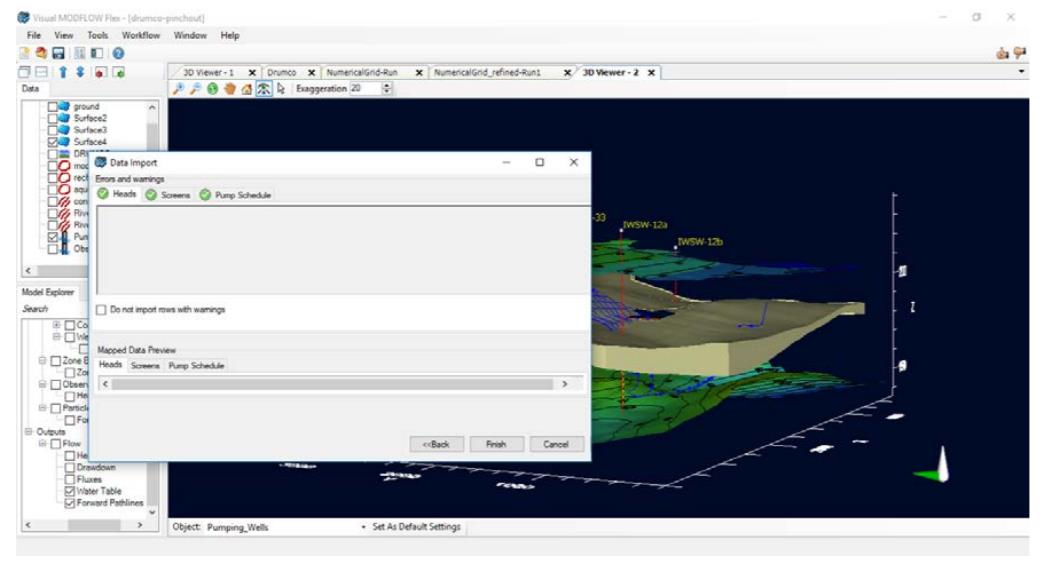
Visual MODFLOW Flex不仅仅是MODFLOW地下水模拟的图形用户界面。Visual MODFLOW Flex是行业标准规范软件,将地下水流和污染物运移、基本分析和校准工具,以及令人惊叹的三维可视化功能集成在一个单一的,易于使用的软件环境中。
使用Visual MODFLOW Flex,用户将拥有所有的工具,可用来解决局部区域范围内的水质、地下水补给和水源的保护问题。
灵活的建模方法
Visual MODFLOW Flex允许您选择用于建立地下水模型的建模方法。选择灵活的有效的conceptual modeling approach或classical modeling approach。
Conceptual Modeling Approach
使用现有的GIS数据和钻井/钻孔来构建3D概念模型。立的网格概念模型提供了不同网格类型和模拟器。为您自动计算单元格位置和参数,从而减少在基于单元格的级别上手动定义这些位置和参数的需要。从一个概念模型中,您可以轻松地生成不同网格类型和建模场景的多个数值模型,并根据需要更新或修改模型。
Classical Numerical Modeling Approach
理想的模型具有简单的地质,基本属性和边界条件,classical approach
可以让您从定义数字网格开始。然后,网格可以使用传统技术手工填充属性和边界条件。
整合三维概念和地下水数值模拟
在一个单一的直观的建模环境中,提供了从原始数据到概念模型到数值模型的无缝转换。
利用钻孔测井资料和剖面确定复杂地质模型层
解释GIS数据以定义立于网格的水文地质属性和边界
使用2D、3D和横截面视图中的原始数据运行、分析和验证模型结果
生成多个概念,在并行的单个项目中生成多个数值网格和场景模型
通过比较在2D,3D或图表视图中运行的多个模型的头来评估不确定性

In some cases, not all wells are included when exporting data from the Calc. vs Obs. Chart
In some cases, linear boundary condition features were skipped during conceptual to numerical model conversion.

Conceptual Modeling Approach
Build your 3D conceptual model using existing GIS data and wells/boreholes. The grid-independent conceptual model gives you the flexibility to experiment with different grid types and simulators. Cell locations and parameters are automatically calculated for you, reducing the need to define these manually on a cell-based level. From one conceptual model you can easily generate multiple numerical models of different grid types and modeling scenarios, and easily update or modify the model as needed. Learn more »

Visual MODFLOW Flex Applications
Visual MODFLOW Flex can be used for an array of groundwater applications.
Delineate well capture zones for domestic water supply development
Design and optimize pumping well locations for mine dewatering projects
Determine contaminant fate and exposure pathways for risk assessment
Simulate surface water-groundwater interactions
Watershed scale/regional groundwater modeling
Evaluate groundwater remediation systems (pump and treat, funnel and gate etc)
Aquifer storage and recovery (ASR)
Evaluate saltwater intrusion
科学软件网的客户涵盖产品涵盖教育、、交通、通信、金融、保险、电力等行业,并且为诸如北京大学、*大学、中国大学、中科院、农科院、社科院、环科院、国家、交通部、南方电网、国家电网、许继、南瑞等国内大型企事业单位、部委和科研机构长期提供相关产品。我们的品质,值得您信赖
http://turntech8843.b2b168.com


