使用期限*
许可形式单机
原产地美国
介质下载
适用平台windows
科学软件网专注提供科研软件。截止目前,共代理千余款,软件涵盖各个学科。除了软件,科学软件网还提供课程,包含34款软件,66门课程。热门软件有:spss,stata,gams,sas,minitab,matlab,mathematica,lingo,hydrus,gms,pscad,mplus,tableau,eviews,nvivo,gtap,sequncher,simca等等。
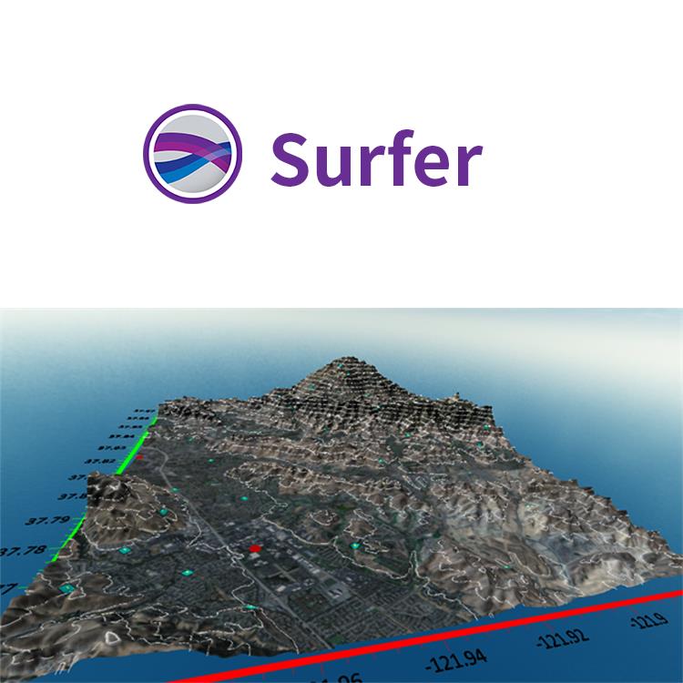
编辑轮廓
编辑轮廓线到精细的细节。Surfer的网格编辑器可以通过交互式编辑底层网格文件,快速调整等高线。刷、翘曲、平滑、向下推或向上推、网格节点,并立即看到您基于网格地图的变化。
执行徒手曲线编辑
通过节点刷特定Z值
平滑轮廓
在特定区域拉起或推下等高线
弯曲轮廓线
擦除等高线图的部分地方
在任何XY点位置找到z值
确定性网格数据
Surfer对您模型的准确性完全有信心。Surfer提供了大量的插值方法,将规则或不规则的数据网格化到网格或栅格上,并且每个插值对网格参数提供完全控制。另外,使用多线程网格也不会浪费时间。
Surfer网格化方法
Kriging
距离倒数
小曲率
See all the details of your image map. The number of colors used to display images maps has been significantly increased from 256 colors to up to 16 million colors, allowing smaller color variations to be discernible.

Surfer 2D/3D测绘、建模分析软件

Streamlined Workflows
You will be up and running in matter of minutes. Surfer’s user interface was designed to take the guesswork out of learning a new program. We worked hard to streamline workflows so you don’t have to.
Surfer User Interface Features
Welcome dialog to get you started
Map wizard to quickly create maps and models
Customize ribbon and quick access toolbar
Dock or float all windows
Single window to view, edit, and manipulate the data and maps
Contents window to easily manage layers of maps and models
Properties window for quick feature editing
Worksheet window to view or edit raw data

Make Meaningful Decisions
Get answers to your questions with Surfer’s geoprocessing tools. Process your data and analyze relationships. Narrow down areas of interest, highlight important intersections, or perform mathematical calculations on the underlying data to make informed decisions.
Surfer Geoprocessing Tools
View, create, edit and delete object attributes using the convenient Attribute Table
Calculate attribute values
Query objects based on attribute values
Perform Delaunay triangulation
Reshape, simplify, smooth polylines, polygons, and grids
Create buffers around points, polylines, and polygons
Convert between polygons and polylines
Create polygons by combining existing polygons
Create points or polygons in intersecting areas
Connect or break polylines at specified locations
Combine and split islands
Georeference images
Crop images
Set a color in an image to be transparent
科学软件网专注提供正版软件,跟上百家软件开发商有紧密合作,价格优惠,的和培训服务。
http://turntech8843.b2b168.com