使用期限*
许可形式单机和网络版
原产地美国
介质下载
适用平台windows
科学软件网提供大量正版科学软件,满足各学科的科研要求。科学软件网专注软件销售服务已达19年,全国大部分高校和企事业单位都是我们的客户。同时,我们还提供本地化服务,助力中国的科研事业。
创建变异函数
GS+使您可以完全控制变差函数参数,如主动滞后距离和个体滞后类的大小。默认值提供了合理的起点,您可以优化分析以适应特定的数据集。
自动创建变差函数模型---可以自动创建kriging模型,大程度地使用迭代技术来优化您的数据,以优化良好的模型拟合。模型窗口允许您覆盖GS+选择的值,滑动条控件允许您立即看到更改的结果。GS+为几乎所有的kriging应用程序提供足够的模型。
由于数据异常,变差函数有时是不规则的---当它们是的值时,它们就会变得很明显,而不是与其他值在特定的范围内自动关联。GS+提供了h散射图和方差云分析,使您能够快速地可视化和识别异常值,并且新的掩饰命令允许您像手术一样移除(暂时或地)违规数据记录。定向变异(各向)函数是同时产生的各向同性的变量,所以您可以很*地评估自相关是否依赖于罗盘的方向。例如,当存在一个斜率效应或其他环境特征时,在一个方向上的自相关与另一个方向的自相关是不同的。
But don't take our word for it
Take the word of the hundreds of scientists and engineers who have cited GS+ in their research publications – over 100 in 2019 alone. Or the hundreds of users at universities, government and non-governmental research institutes, and various industries in almost every country in the world.
GS+ means geostatistics
Geostatistics is not an add-on feature of GS+ – it is the heart of the software. Many of our users have access to other geostatistics tools within their favorite GIS or mapping programs, but come to GS+ for their serious geostatistical analyses. Because GS+ output is compatible with industry standards, GS+ can be used directly with many of these other programs. Or it can be used standalone – GS+ has its own data worksheet (which also accepts Excel, Access, and other types of data files) and produces its own maps.

Frequency distributions provide information about the normality of a particular data analysis set.

创建可由许多其他程序使用的内插输出文件
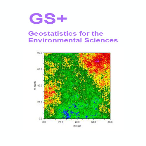
GS+创建插值输出文件(从kriging、cokriging、模拟或逆距离技术),可以读取到许多其他类型的映射程序。GS+将使用这些文件来创建它自己的地图,或者您可以将数据读入支持ARCIFIO®或Surfver®输入格式的任何GIS或映射程序中。
交叉验证允许您根据采样数据测试插值系统
在交叉验证分析中,空间域中的每个测量点被单地从域中移除,并且通过Kriging或逆距离加权来估计其值,尽管它**存在过。以这种方式,可以构造域中每个样本位置的估计值与实际值的图,并用于测试插值系统。
自定义您的GS+图形和地图的所有细节,并发布到任何地方
一组丰富的图形编辑选项允许您更改轴、字体、图、标题、符号和许多其他图形属性。可以将地图和图形打印或发送到Windows剪贴板或可由Web浏览器、文字处理器或接受WMF、JPEG、PNG或BMP格式的任何其他Windows程序读取的文件。
系统需求
GS+软件只适用于Windows系统。
Interpolation methods to meet every need
Three different types of interpolation are provided by GS+. Ordinary kriging (both block and punctual) provide optimal estimates for a property across the spatial domain. Conditional simulation also provides optimal estimates but honors original data at their locations so can be used to map sharp boundaries in a domain. Inverse distance weighting is probably the best non-geostatistical interpolation technique, based on simple nearest neighbor calculations.
GS+ also provides cokriging, which can be useful when your primary data are supported by secondary data collected at many additional locations. Cokriging is available for both block and punctual kriging and co-located cokriging is available for conditional simulation.
Polygon masks allow you to include or exclude complex shapes in the domain being mapped. Interpolate across an island or avoid interpolating across a parking lot – you can also nest polygons and overlap them.

About Gamma Design Software, LLC
Gamma Design Software was started in 1988 to bring geostatistics to Windows workstations and desktop computers. At that time fast geostatistics software was available only for supercomputers, and other users needed to compile FORTRAN source code on their own. Since then, Gamma Design has been a world leader in providing accessible, powerful, and easy-to-learn geostatistics software for the evolving Windows environment.
2020年,北京天演融智软件有限公司申请高等教育司产学合作协同育人项目,“大数据”和“机器学习”师资培训项目,以及基于OBE的教考分离改革与教学评测项目已获得批准。我们将会跟更多的高校合作,产学融合协同育人。
http://turntech8843.b2b168.com