使用期限*
许可形式单机
原产地美国
介质下载
适用平台windows
科学软件网提供的软件覆盖各个学科,软件数量达1000余款,满足各高校和企事业单位的科研需求。此外,科学软件网还提供软件培训和研讨会服务,目前视频课程达68门,涵盖34款软件。
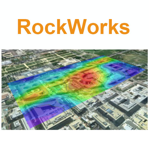
RockWorks 地质建模软件
RockWorks是创建二维和三维地图、日志和断面的地质模型、量报告以及一般地质图为环境、程、采矿和石油工业的综合软件程序。RockWorks是石油、环境、岩土和采矿业的标准软件,用于地表和地下数据可视化,包括地图、原木、横断面、栅栏图、实体模型和体积计算等常用工具。
RockWorks为分析地表和地下数据提供多种选项,并接受不同的文件类型,如地层、岩性、井下地球化学/地球物理学/岩土测量、颜色间隔、裂缝和含水层数据等。内置的2D和3D查看/编辑窗口的RockWorks graphic output可导出图形,或导出到CAD、Google Earth和GIS程序中。使用ReportWorks模块可为报表和海报生成页面布局。
RockWorks提供以下三个版本供选择
Basic:所有实用程序,加钻孔管理地图,日志,日志部分。
Standard:包含Basic功能,还包含了井眼管理建模:岩性,地层,地球物理/地球化学/程,含水层,颜色,裂缝。
Advanced:包含Standard功能,还包含了SQL-server数据库支持、程序自动化(脚本)、3D断层、钻井管理石油生产图。
Native SQLite Database Support:
RockWorks 17 advances its database support by moving to native SQLite database support. SQL Server continues to be supported.
SQLite is an in-process library that implements a self-contained, serverless, zero-configuration, transactional SQL database engine. SQLite is an embedded SQL database engine. Unlike most other SQL databases, SQLite does not have a separate server process; it reads and writes directly to ordinary disk files. A complete SQL database with multiple tables, indices, triggers, and views, is contained in a single disk file. SQLite responds gracefully to memory allocation failures and disk I/O errors. Transactions are ACID* even if interrupted by system crashes or power failures.ACID: Atomicity, Consistency, Isolation, Durability
Compact or Expanded Displays:
Keep track of your project dimensions and coordinates without crowding out your other data. Dimensions and coordinates can be displayed in a compact mode at the top of the RockWorks 17 window, or expanded out for editing.

All three levels also include the Borehole Manager and its local database for storing and managing borehole-based data. Here is where the feature levels apply:
With Basic, the borehole processing tools are limited to observed data – no modeling: Borehole location maps, 2D and 3D strip logs, and striplog profiles and cross sections. Simple correlation panels are offered for Stratigraphy, I-Data, and P-Data in 2D section diagrams. Basic users can create playlists with up to 5 items each, and can manage three 3D faults.
With Standard, you get all of the borehole modeling tools for the subsurface data offered in the Lithology, Stratigraphy, I-Data, T-Data, P-Data, Fractures, Aquifers, and Vectors menus, and all of the 2D and 3D diagrams and maps these menus contain. Standard users can create playlists with up to 5 items each, and can manage three 3D faults.
With Advanced, you can connect to a SQL-Server database on a network, create playlists with unlimited items, run RockWorks command scripts for advanced automation, apply unlimited 3D faults to surface and solid models. You also have access to the tools in the well Production menu, and can import commercial PLSS land grids, (Read more about RockWorks Advanced.)

Diagram Embellishments
To eliminate additional steps in combining and appending diagrams, common embellishments have been added to the programs that create sections, profiles, projected sections, maps, 3D diagrams and charts.
Sections, Profiles & Projected Sections – Additional diagram layers include perimeter annotation, surface profiles, faults, infrastructure, up to five 2D graphics overlays, peripheral annotation (titles, title blocks, legends, and image), and a border.

RockWorks是创建二维和三维地图、日志和断面的地质模型、量报告以及一般地质图为环境、程、采矿和石油工业的综合软件程序。RockWorks是石油、环境、岩土和采矿业的标准软件,用于地表和地下数据可视化,包括地图、原木、横断面、栅栏图、实体模型和体积计算等常用工具。
RockWorks为分析地表和地下数据提供多种选项,并接受不同的文件类型,如地层、岩性、井下地球化学/地球物理学/岩土测量、颜色间隔、裂缝和含水层数据等。内置的2D和3D查看/编辑窗口的RockWorks graphic output可导出图形,或导出到CAD、Google Earth和GIS程序中。使用ReportWorks模块可为报表和海报生成页面布局。
RockWorks提供以下三个版本供选择
Basic:所有实用程序,加钻孔管理地图,日志,日志部分。
Standard:包含Basic功能,还包含了井眼管理建模:岩性,地层,地球物理/地球化学/程,含水层,颜色,裂缝。
Advanced:包含Standard功能,还包含了SQL-server数据库支持、程序自动化(脚本)、3D断层、钻井管理石油生产图。
License Level
Basic
Standard
Advanced
Utilities (including EarthApps)
√
√
√
Logs & Sections
√
√
√
Borehole-Based Modeling
√
√
SQL Server, Automation, 3D Faulting
√
科学软件网专注提供正版软件,跟上百家软件开发商有紧密合作,价格优惠,的和培训服务。
http://turntech8843.b2b168.com