使用期限租赁和*
许可形式单机和网络版
原产地美国
介质下载
适用平台windows
科学软件网提供的软件覆盖各个学科,软件数量达1000余款,满足各高校和企事业单位的科研需求。此外,科学软件网还提供软件培训和研讨会服务,目前视频课程达68门,涵盖34款软件。
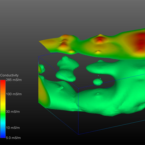
地质统计学功能
MVS地质统计学模块被用来估计黄金浓度使用所有可用的分析数据。所有地区的非盟级以上30磅的显示,根据地层学与矿色。
站点分析
MVS用于分析、规划和可视化的土壤修复前在加州中部天然气加工厂。
矿体和污染羽状物
MVS重要的功能之一是计算矿体或污染羽表土。使用它,您可以快速确定提取柱所需的坑。地球物理参数如坑壁坡度和挖掘精度的计算。
复杂的三维建模
MVS能够模拟复杂的地形学的关系。断层、地垒、地堑、褶皱复杂的三维模型,盐丘和其他许多复杂的地质结构使用MVS很*创建。
Each major release of Earth Volumetric Studio includes a corresponding release of Earth Volumetric Studio Sample Projects. Each project folder includes a number of applications which strive to introduce all major modules in Studio with real-world examples provided by our customers over our 27 year history. The video below shows the outputs from 180+ applications in the August 2016 Earth Volumetric Studio Projects. In under 10 minutes you’ll get a comprehensive overview of the breadth of projects which Studio can tackle.

体绘制
EVS Pro的体绘制提供了代表污染物羽流的另一种完全三维可视化技术。

Geologic Modeling
Surface Based Hierarchical Layer Models
G
Smooth Geologic Indicator Kriging
G – Size and complexity Limits
Incorporate Surficial Geology with Smooth Geologic Indicator Kriging

Chemistry Or Parameter Estimation
2D Parameter Estimation Using Expert System Driven Kriging
Subset 3D Data Using Average, Maximum, or Slice at Elevation
Automatic 2D Adaptive Grid Refinement
科学软件网为全国大多数高校提供过产品或服务,销售和售后团队,确保您售后**!
http://turntech8843.b2b168.com