使用期限*
许可形式单机
原产地美国
介质下载
适用平台windows
科学软件网提供的软件上千款,涉及所有学科领域,您所需的软件,我们都能提供。科学软件网提供的软件涵盖领域包括经管,仿真,地球地理,生物化学,工程科学,排版及网络管理等。同时,还提供培训、课程(包含34款软件,66门课程)、实验室解决方案和项目咨询等服务。
Make Meaningful Decisions
Get answers to your questions with Surfer’s geoprocessing tools. Process your data and analyze relationships. Narrow down areas of interest, highlight important intersections, or perform mathematical calculations on the underlying data to make informed decisions.

Create Professional Maps
Easily communicate both simple and complex spatial data. Surfer gives you the tools to create high-quality maps to clearly deliver your message to coworkers, clients, and stakeholders.
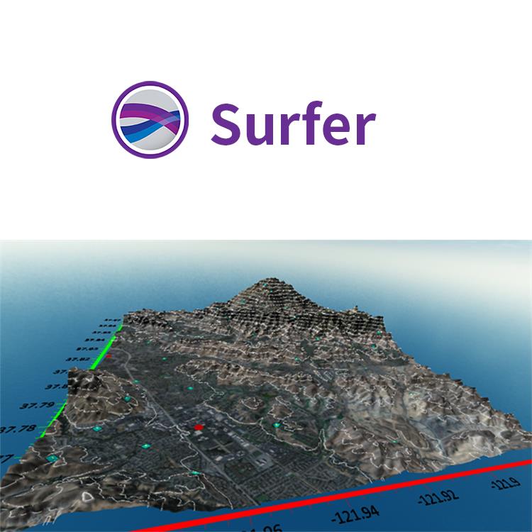
Surfer Map Types
Contour
Base
Post
3D Surface
Color Relief
Classed Post
3D Wireframe
1-Grid Vector
2-Grid Vector
Watershed
Grid Value
Viewshed
Point Cloud

Surfer适用的行业包括
农业
考古
建筑
教育
能源
环境
勘探
地球物理
程
地热
地理信息系统
海事
军事
采矿
泥浆录井
石油与天然气
可再生能源
无人机
公共事业
水利
创建的地图
轻松沟通简单和复杂的空间数据。Surfer提供创建高质量地图工具,可以清楚的向同事、客户和利益相关者传统信息。
Use Data in Date/Time Format
Visualize your data with respect to time! Surfer 12 supports dates and times as v alid data. This means you can use dates and times as a data variable for gridding, for creating post maps, and you can format data in the workshe et or text labels in multiple date and time formats.
< span>
Grid and Display Maps with Logarithmic Z Scale
Effectively display Z data that range over s everal orders of magnitude! You can grid data taking the log of the Z value prior to gridding, choose to have logarithmically scaled contour levels, or h logarithmic scaling applied to the color scale. This is extremely useful when your data file has extreme data ranges, such as concentration data where t he Z values can span multiple orders of magnitude (i.e. >1 to<20000).

Surfer 具有的强大插值功能和绘制图件能力,使它成为用来处理XYZ数据的软件,是地质工作者*的成图软件。可以轻松制作基面图、数据点位图、分类数据图、等值线图、线框图、地形地貌图、趋势图、矢量图以及三维表面图等;提供11种数据网格化方法,包含几乎所有流行的数据统计计算方法;提供各种流行图形图像文件格式的输入输出接口以及各大GIS软件文件格式的输入输出接口,大大方便了文件和数据的交流和交换;提供新版的脚本编辑引擎,自动化功能得到较大加强。
全网格控制
Surfer可以对网格文件进行广泛的控制。创建用于构造地质学等厚图,计算地形分析库存管理或物的数量,甚至使用网格文件创建站点适合性模型。实现 对底层数据的全面理解。
Surfer网格特征
直接编辑底层网格数据
计算网格的体积和面积
加、减、乘、除网格
在网格上执行自定义数学函数
计算微分积分运算或傅立叶和光谱分析
转换领域到nodata中
将网格从一个坐标系统投射到另一个坐标中
无缝拼接多个网格
变换、缩放、旋转、偏移或镜像网格
具有高或低通滤波器的滤波器网格
从网格中提取较小区域
从原来的z中减去网格中的z
19年来,公司始终秉承、专注、专心的发展理念,厚积薄发,积累了大量的人才、技术以及行业经验,在行业内得到了大量用户的认可和高度价。
http://turntech8843.b2b168.com