使用期限*
许可形式单机和网络版
原产地加拿大
介质下载
适用平台windows
科学软件网提供软件和培训服务已有19年,拥有丰富的经验,提供软件产品上千款,涵盖领域包括经管,仿真,地球地理,生物化学,工程科学,排版及网络管理等。同时还有的服务,现场培训+课程,以及本地化服务。
Visual MODFLOW Flex地下水流动与污染物运移模拟软件
Visual MODFLOW Flex不仅仅是MODFLOW地下水模拟的图形用户界面。Visual MODFLOW Flex是行业标准规范软件,将地下水流和污染物运移、基本分析和校准工具,以及令人惊叹的三维可视化功能集成在一个单一的,易于使用的软件环境中。
使用Visual MODFLOW Flex,用户将拥有所有的工具,可用来解决局部区域范围内的水质、地下水补给和水源的保护问题。
为什么选择Visual MODFLOW Flex?
更快更有效地构建模型
使用integrated 3D conceptual modeling,用户*重复构建模型。模型输入和网格设计可以在建模过程中的任何时刻更新,随着建模对象发生变化,更多的数据被收集,从而更好地理解地表面的情况。
简单、易于使用
自1995年,Visual MODFLOW就以它的直观、易于使用的界面被用户熟知。Visual MODFLOW Flex中的建模步骤呈现在直观的、工作流驱动的图形用户界面中,允许您查看已经完成的步骤、当前步骤以及需要完成哪些步骤以达到建模目标。
Build models faster and more efficiently
With integrated 3D conceptual modeling, you will never have to rebuild a model again. Model inputs and grid design can be updated at any point in the modeling process as modeling objectives change, more data are collected and a better understanding of the sub-surface is achieved.
Simple, easy-to-use
Since 1995, Visual MODFLOW has been recognized for its intuitive, easy-to-use interface. With Visual MODFLOW Flex, modeling steps are conveniently presented in an intuitive, workflow-driven graphical user interface, allowing you to see what steps you’ve completed, your current step and what steps you need to finish to reach your modeling objectives.

自信地建模
3D概念建模功能允许您轻松地解释和分析2D、3D和横截面阅读器中的原始GIS数据。提供了数据可视化的质量保证,并使您在设计数值模型之前对地下系统有了更深入的了解。

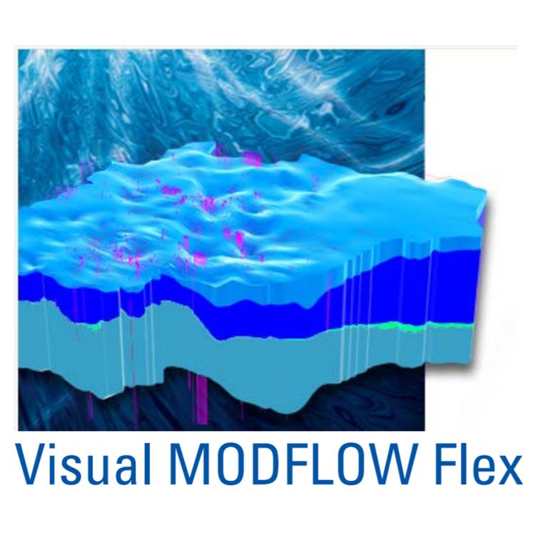
强大的数据可视化功能
新三维可视化技术的构建与设计,Visual MODFLOW Flex 让您的水文地质模型给人印象深刻的视觉效果,并允许您有效地向同事和利益相关者展示和交流您的数据。
可视化所有的数据,包括的2D,3D和多视图(Flexviewer)显示的概念对象、计算网格、数据输入(属性区域、边界条件单元格)和输出数据(计算上端、迹线、水位)
创建切割和横截面视图,并让您在模型中查看
为报表或Web生成3D动画和电影
添加等值线、等高线,迹线和色差到阅读器中
在三维表面上叠加栅格图像(站点地图,卫星图像)以显示浮雕效果
优化OpenGL图形以增强硬件渲染

Model with confidence
The 3D conceptual modeling capabilities allow you to easily interpret and analyze raw GIS data in 2D, 3D and cross-sectional viewers. This provides a visual quality assurance of the data and allows you to gain a solid understanding of the subsurface before designing the numerical model.
科学软件网不定期举办各类公益培训和讲座,让您有更多机会免费学习和熟悉软件。
http://turntech8843.b2b168.com