使用期限*
许可形式单机和网络版
原产地美国
介质下载
适用平台Windows
科学软件网提供软件和培训服务已有19年,拥有丰富的经验,提供软件产品上千款,涵盖领域包括经管,仿真,地球地理,生物化学,工程科学,排版及网络管理等。同时还有的服务,现场培训+课程,以及本地化服务。
Visualize Data
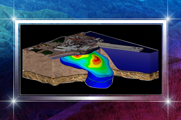
Eliminate subsurface uncertainty. Achieve insight and clarity by transforming raw, subsurface data into understandable well logs, borehole models, and cross sections/profiles. Easily create professional geotechnical reports that clearly communicate important information with Strater.

Strater 地质数据处理软件
概述
可视化数据
消除地表下的不确定性。通过将原始的地下数据转换成可理解的测井曲线、井眼模型和横断面,实现洞察力和清晰度。轻松创建的岩土技术报告,清晰地与Strater沟通重要信息。
分析数据
找到您所有地下数据问题的。当在Strater中显示时,地下数据变得清晰易懂。Strater的广泛功能让您可以快速查看和分析领域,而不会忽略一些细节。
Golden Software is excited to announce the release of Strater. Strater is a well log and borehole plotting software program that imports your data from a multitude of sources (database files, data files, LAS files, ODBC, and OLE DB data sources). Strater provides innumerable ways to graphically display your data. All the logs are fully customizable to suit your needs.

Project Files lists all of the files in the selected project directory. After clicking Project Files the first time, a Select Folder dialog appears. Select the directory on the computer that should be used as the Project Files directory and click Select Folder. All of the files from the selected directory are listed. Click on any file in the list and click the Open button to open the selected file. Click the Set Project Folder button to change the directory, or change the Default path directory in the Options dialog General page.

Strater 地质数据处理软件
概述
可视化数据
消除地表下的不确定性。通过将原始的地下数据转换成可理解的测井曲线、井眼模型和横断面,实现洞察力和清晰度。轻松创建的岩土技术报告,清晰地与Strater沟通重要信息。
分析数据
找到您所有地下数据问题的。当在Strater中显示时,地下数据变得清晰易懂。Strater的广泛功能让您可以快速查看和分析领域,而不会忽略一些细节。
沟通结果
将数据转化为利润。轻松地向客户、利益相关者和同事传达重要信息。不管数据有多复杂,Strater的可视化能力都有助于对地下数据的全面和透彻的理解。
增强地质模型
好地表示数据。显示地下数据与Strater的众多定制选项。实际上,Strater的日志、模型和横截面的每个方面都是可定制的。
Strater自定义选项
包括标题、轴、标尺和图例
绘制文本、折线、多边形、符号和样条折线
应用基于行业标准的预定义或自定义填充模式
根据需要使用工具对齐、覆盖或分发日志
生成可与同事共享和跨多个项目重用的自定义填充库
创建标准化模板来创建一致的报告
包括定制的页眉和页脚
科学软件网主要提供以下科学软件服务:
1、软件培训服务:与国内大学合作,聘请业内人士定期组织软件培训,截止目前,已成功举办软件培训四十多期,累计学员2000余人,不仅让学员掌握了软件使用技巧,加深了软件在本职工作中的应用深度,而且也为**业人士搭建起了沟通的桥梁;
2、软件服务:提供软件试用版、演示版、教程、手册和参考资料的服务;
3、解决方案咨询服务:科学软件网可向用户有偿提供经济统计、系统优化、决策分析、生物制药等方面的解决方案咨询服务;
4、软件升级及技术支持服务:科学软件网可向用户提供软件的本地化技术支持服务,包括软件更新升级、软件故障排除、安装调试、培训等;
5、行业研讨服务:科学软件网会针对不**业,邀请国内外以及软件厂商技术人员,不定期在国内举办大型研讨会,时刻关注*技术,为国内行业技术发展提供导向。
http://turntech8843.b2b168.com