使用期限*
许可形式单机
原产地美国
介质下载
适用平台windows
科学软件网专注提供科研软件。截止目前,共代理千余款,软件涵盖各个学科。除了软件,科学软件网还提供课程,包含34款软件,66门课程。热门软件有:spss,stata,gams,sas,minitab,matlab,mathematica,lingo,hydrus,gms,pscad,mplus,tableau,eviews,nvivo,gtap,sequncher,simca等等。
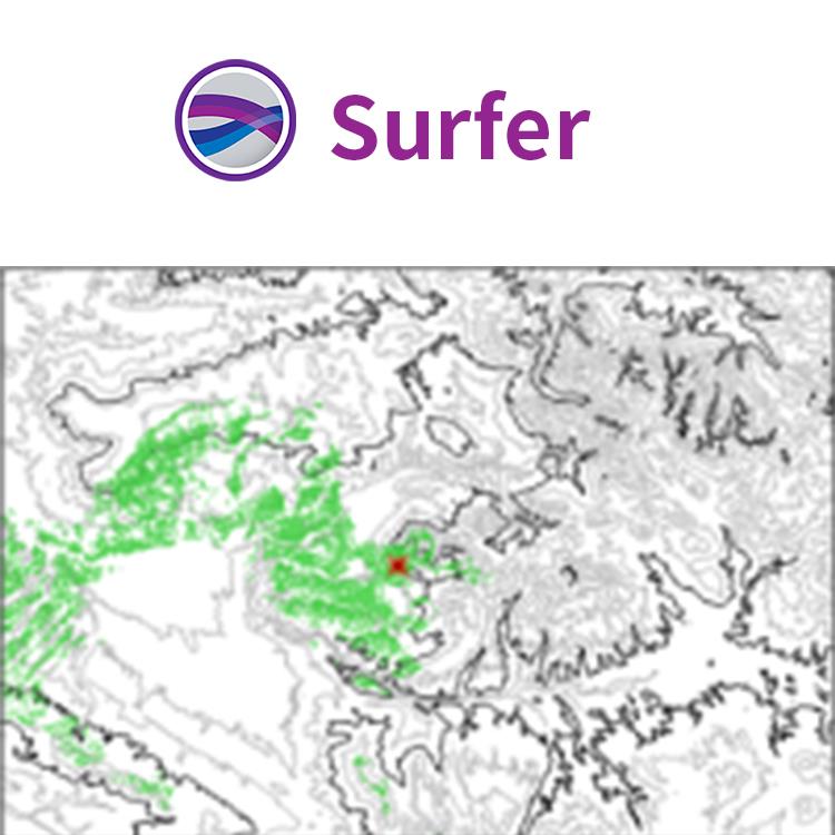
Surfer是美国Golden Software 公司编制的一款以画三维图(等高线,image map, 3d surface)的软件。该软件具有的强大插值功能和绘制图件能力,使它成为用来处理XYZ数据的软件,是地质工作者*的成图软件。
LiDAR点云
LiDAR在许多领域,包括考古学、测量学、地理信息系统等成为越来越流行的数据收集方法。使用Surfer广泛的激光处理和可视化功能,利用LiDAR提供的所有优势。
LiDAR点云功能
从多个LAS/LAZ文件中创建一个点云
通过高程、强度、返回数或分类来分配颜色
交互式或按标准选择点
、重分类或删减来选择点
从点云中创建网格或导出到LAS/LAZ
在3D视图中可视化数据的所有方面
Surfer的LAS/LAZ过滤选项
基于XY边界或高程数据限制的空间滤波
导入每个Nth点
只导入期望的返回类型或分类值
用源ID导入数据
标志过滤器,如扫描方向、飞行边缘,或合成、关键和保留点。

Surfer Interpolation Features
Variogram models
Anisotropy
Kriging with external drift
Faults and breaklines
Control over search neighborhood size, shape, and constraints
Data filtering
Automatic data statistics
Create grid files directly from contour polylines
Grid to convex hull
Duplicate handling
Cross validation
Control over output geometry and resolution
Limit or clamp z-values

Surfer 软件 美国Golden Software 公司编制的一款以画三维图(等高线,image map, 3d surface)的软件。该软件简单易学,可以在几分钟内学会主要内容,且其自带的英文帮助(help菜单)对如何使用该软件解释的很详细,其中的tutorial教程更是清晰的介绍了surfer的简单应用。
简化工作流程
几分钟内Surfer就可以正常工作起来。Surfer的用户界面是为了猜测学习新程序的可能性。
Surfer用户界面的功能特征
欢迎对话框开始您的工作
地图向导快速让您生成地图和模型
自定义色带和快速访问工具栏
所有窗口停靠或浮动
单个窗口查看、编辑和操作数据和地图
内容窗口轻松管理图层和模型的图层
用于快速编辑功能的属性窗口
工作表窗口查看或编辑原始数据
扩展地图和建模功能
Surfer提供了可视化和建模所有类型数据的工具。不仅如此,Surfer广泛的定制选项允许您以易于理解的方式传达复制的想法,用各种自定义选项扩展地图和建模功能。
Surfer自定义选项
添加图例、截面、放大镜、比例尺和多轴
包括页眉和页脚
应用线性或对数颜色刻度
调整倾斜、旋转和视场角
编辑所有轴参数
包括网格线或另一个网格
组合或叠加多个地图
定义自定义线条样式和颜色
编辑文本、行、填充和符号属性
添加文本、折线、多边形、符号和样条线
包括范围环

简化工作流程
几分钟内Surfer就可以正常工作起来。Surfer的用户界面是为了猜测学习新程序的可能性。
Surfer用户界面的功能特征
欢迎对话框开始您的工作
地图向导快速让您生成地图和模型
自定义色带和快速访问工具栏
所有窗口停靠或浮动
单个窗口查看、编辑和操作数据和地图
内容窗口轻松管理图层和模型的图层
用于快速编辑功能的属性窗口
工作表窗口查看或编辑原始数据
扩展地图和建模功能
Surfer提供了可视化和建模所有类型数据的工具。不仅如此,Surfer广泛的定制选项允许您以易于理解的方式传达复制的想法,用各种自定义选项扩展地图和建模功能。
Take Advantage of the Post Map and Classed Post Map Enhancements
Create your post maps the way you want them! Many new enhancements have been made to post and classed post maps so that you can create the map you envision. Add multiple labels to points,connect the points with a line, and use the symbol color as the label font color, to name a few.
Post maps also offer the ability to color the symbols using a column in the data file of either numeric values (and you can choose a color gradient to apply to the data range) or discrete color names. Classed post maps offer the option to apply a color gradient to the symbols, apply a gradational size to the symbols, and set the symbol properties for all symbols at once.
,专注,专心是科学软件网的服务宗旨,开发的软件、传递*的技术、提供贴心的服务是我们用实际行动践行的**目标,我们会为此目标而不懈努力。
http://turntech8843.b2b168.com