使用期限*
许可形式单机和网络版
原产地加拿大
介质下载
适用平台windows
科学软件网提供的软件上千款,涉及所有学科领域,您所需的软件,我们都能提供。科学软件网提供的软件涵盖领域包括经管,仿真,地球地理,生物化学,工程科学,排版及网络管理等。同时,还提供培训、课程(包含34款软件,66门课程)、实验室解决方案和项目咨询等服务。
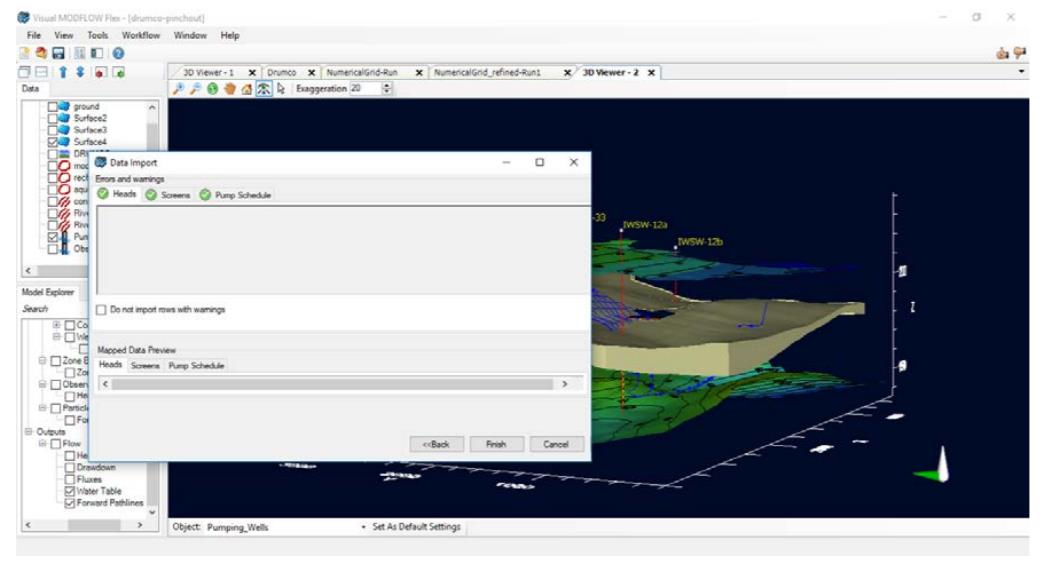
Visualize all data, including conceptual objects, numerical grids, input data (property zones, boundary condition cells) and output data (calculated heads, pathlines, water table) in state-of-the-art 2D, 3D and multi-view (FlexViewer) displays

Full GIS Integration
Easily construct your grid-independent hydrogeologic conceptual model in minutes using existing GIS data sets.

Visual MODFLOW Flex is more than a graphical user interface for MODFLOW groundwater simulations. Visual MODFLOW Flex brings together industry-standard codes for groundwater flow and contaminant transport, essential analysis and calibration tools, and stunning 3D visualization capabilities in a single, easy-to-use software environment.

构建更大更复杂的模型
Visual MODFLOW Flex具备处理大量详细、高分辨率数据的能力。支持64位系统,您可以利用64位计算机上可用的额外内存,模拟大型复杂的区域尺度地下水系统。
构建可靠的模型
通过集成建模,模型输入和输出可以很*地与原始GIS字段数据一起可视化。这使您可以通过演示如何从概念数据(钻孔记录、地理信息系统数据)生成数值模型数据(模型层、流参数、回灌数据)来建立模型可信度。计算上端和迹线也可以与概念模型数据一起显示,以验证假设并进一步模型可信性。
轻松比较多个模型
Visual MODFLOW Flex的特设计允许简单地比较多个模型,让您评估替代建模方案、网格的不严谨和水文地质解释。
快速上手
提高您的技术知识,并没收成为一个,拥有丰富的学习和支持资源,包括循序渐进的教程、全面的用户指南、视频、在线培训课程和免费的网络研讨会。
地下水综合建模
Visual MODFLOW Flex有一整套应对水质、地下水供应必要的工具和水源保护措施,包括:
MODFLOW-2000, 2005, NWT 世界地下水流模拟标准
MODFLOW-USG 使用非结构网格的MODFLOW有限体积版本
MODFLOW-LGR 共享节点的局部网格细化(LGR)为区域尺度的模拟
MODFLOW-SURFACT 复杂饱和/非饱和地下水流和运输过程的强化模拟
SEAWAT 变密度地下水流与多物种溶质运移耦合模型
MT3DMS 多物种污染物运移模拟的标准包
RT3D 和多物种反应污染物运移模拟
MODPATH 正反向粒子跟踪标准包
Zone Budget 分区域水分平衡计算包
PEST v.12.3 支持试验点的自动校准和灵敏度分析
Save time and money
Visual MODFLOW Flex provides both GIS-based 3D conceptual modeling and numerical modeling all within a single integrated software environment. This reduces the need to maintain costly 3rd party pre-processing tools and eliminates the error-prone process of transferring data back-and-forth between different software packages and data formats.
Model with confidence
The 3D conceptual modeling capabilities allow you to easily interpret and analyze raw GIS data in 2D, 3D and cross-sectional viewers. This provides a visual quality assurance of the data and allows you to gain a solid understanding of the subsurface before designing the numerical model.
科学软件网专注提供正版软件,跟上百家软件开发商有紧密合作,价格优惠,的和培训服务。
http://turntech8843.b2b168.com


