使用期限*
许可形式单机
原产地美国
介质下载
适用平台windows
科学软件网是一个以引进国研软件,提供软件服务的营业网站,网站由北京天演融智软件有限公司创办,旨在为国内高校、科研院所和以研发为主的企业事业单位提供的科研软件及相关软件服务。截止目前,科学软件网已获得数百家国际软件公司正式授权,代理销售科研软件达一千余种,软件涵盖领域包括经管,仿真,地球地理,生物化学,工程科学,排版及网络管理等。同时,还提供培训、课程(包含34款软件,66门课程)、实验室解决方案和项目咨询等服务。
Surfer符号
根据属性值应用行、填充和 符号属性
图例中显示符号
基于特的值选择符号,未归类的颜色和符号和归类的颜色和符号。
即时访问联机数据
Surfer可以让您立即获得**航空影像、开放的街道地图图像、**矢量数据和地形数据如果您有自己喜欢的数据服务器或访问私有数据服务器,请为该数据源包含一个自定义链接以方便访问。Surfer可以很*地访问在线数据的剩余部分。
支持的服务器类型:
网络地图服务器(WMS)
开放的街道地图服务器(OSM)
网络覆盖服务器(WCS)
网络功能服务器(WFS)
与所有坐标系统无缝地协同工作
您的工作是将数据转换为有价值的可视化,而Surfer的功能是将您的工作变得更简单。Surfer轻松管理未引用的数据和数据在不同的多坐标系统投影。
Export all your data! Export a contour map to MIF, SHP, GSB, GSI, BLN or BNA file formats and the Z values are stored as metadata. In addition,when exporting a contour map to KML file, the Z values of the contours are saved as the Object ID for the polyline objects.

Make Meaningful Decisions
Get answers to your questions with Surfer’s geoprocessing tools. Process your data and analyze relationships. Narrow down areas of interest, highlight important intersections, or perform mathematical calculations on the underlying data to make informed decisions.
Surfer Geoprocessing Tools
View, create, edit and delete object attributes using the convenient Attribute Table
Calculate attribute values
Query objects based on attribute values
Perform Delaunay triangulation
Reshape, simplify, smooth polylines, polygons, and grids
Create buffers around points, polylines, and polygons
Convert between polygons and polylines
Create polygons by combining existing polygons
Create points or polygons in intersecting areas
Connect or break polylines at specified locations
Combine and split islands
Georeference images
Crop images
Set a color in an image to be transparent

Make Meaningful Decisions
Get answers to your questions with Surfer’s geoprocessing tools. Process your data and analyze relationships. Narrow down areas of interest, highlight important intersections, or perform mathematical calculations on the underlying data to make informed decisions.

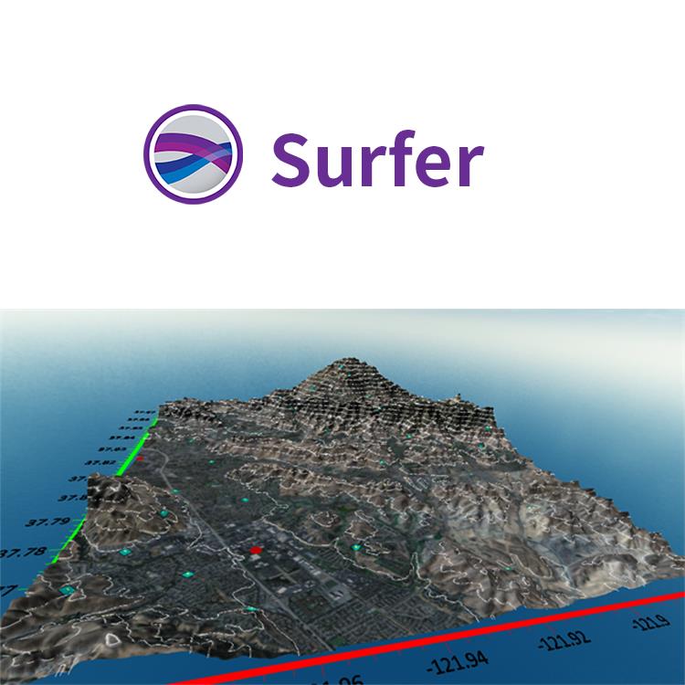
Surfer 2D/3D测绘、建模分析软件
可视化数据
使用Surfer广泛的建模工具以正确的方式显示数据,同时保持准确性和性。用Surfer可以明确的传达您的信息。
LiDAR点云
LiDAR在许多领域,包括考古学、测量学、地理信息系统等成为越来越流行的数据收集方法。使用Surfer广泛的激光处理和可视化功能,利用LiDAR提供的所有优势。
LiDAR点云功能
从多个LAS/LAZ文件中创建一个点云
通过高程、强度、返回数或分类来分配颜色
交互式或按标准选择点
、重分类或删减来选择点
从点云中创建网格或导出到LAS/LAZ
在3D视图中可视化数据的所有方面
Surfer的LAS/LAZ过滤选项
基于XY边界或高程数据限制的空间滤波
导入每个Nth点
只导入期望的返回类型或分类值
用源ID导入数据
标志过滤器,如扫描方向、飞行边缘,或合成、关键和保留点。
Export Map and Drawn Objects in One Step
Save time! Exporting map and non-map objects got a lot easier. No more complicated two-step export process. Now, simply specify the map as the scaling source when exporting your entire project to a vector or georeferenced image file– it’s that easy!
19年来,公司始终秉承、专注、专心的发展理念,厚积薄发,积累了大量的人才、技术以及行业经验,在行业内得到了大量用户的认可和高度价。
http://turntech8843.b2b168.com