使用期限*
许可形式单机
原产地美国
介质下载
适用平台windows
科学软件网提供软件和培训服务已有19年,拥有丰富的经验,提供软件产品上千款,涵盖领域包括经管,仿真,地球地理,生物化学,工程科学,排版及网络管理等。同时还有的服务,现场培训+课程,以及本地化服务。
Enhance Maps & Models
Surfer gives you the tools to visualize and model all types of data, but it doesn’t stop there. Surfer’s extensive customization options allow you to convey complex ideas in an easy to understand manner. Enhance your maps and models with a variety of customizations options.
Surfer Customization Options
Add legends, cross sections, magnifiers, scale bars, and multiple axes
Include headers and footers
Apply linear or logarithmic color scales
Adjust tilt, rotation, and field of view angle
Edit all axis parameters
Include graticule lines or another grid
Combine or stack multiple maps
Define custom line styles and colors
Edit text, line, fill and symbol properties
Add text, polylines, polygons, symbols, and spline polylines
Include range rings
Many more…

Surfer插补功能
Variogram模型
Anisotropy
断层和断裂线
控制搜索邻域大小、形状和约束
数据过滤
自动数据统计
从轮廓线创建网格文件
网格到凸包
重复处理
交叉验证
控制输出几何和分辨率
限制或夹z值
做出有意义的决策
使用Surfer的地理处理工具解答您的问题。处理数据并分析它们之间的关系。缩小感兴趣的区域,**重要的交叉点,或者对基础数据进行数学计算以做出明智的决定。
Surfer处理工具
使用方便的属性表查看、创建、编辑和对象属性
处理Delaunay三角
重塑、简化、平滑折线、多边形和网格
围绕创建点、折线和多边形缓冲区
多边形和折线之间的转换
通过合并现有多边形创建多边形
在相交区域创建点和多边形
在点连接或破折线
合并和分割岛屿
地理参考图像
Get the data you need in the units you want. When measuring lengths and areas on a projected map, you can easily change the units of measure! For example, if your map is in UTM meters, you can measure an area and report the perimeter length in feet and the area in square miles!

Work Seamlessly with all Coordinate Systems
Your job is to transform data into valuable visualizations. Surfer’s job is to make it easy for you. Surfer effortlessly manages unreferenced data and data projected in different/multiple coordinate systems. It really is that easy.

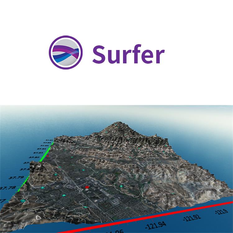
Surfer 软件 美国Golden Software 公司编制的一款以画三维图(等高线,image map, 3d surface)的软件。该软件简单易学,可以在几分钟内学会主要内容,且其自带的英文帮助(help菜单)对如何使用该软件解释的很详细,其中的tutorial教程更是清晰的介绍了surfer的简单应用。
Surfer 具有的强大插值功能和绘制图件能力,使它成为用来处理XYZ数据的软件,是地质工作者*的成图软件。可以轻松制作基面图、数据点位图、分类数据图、等值线图、线框图、地形地貌图、趋势图、矢量图以及三维表面图等;提供11种数据网格化方法,包含几乎所有流行的数据统计计算方法;提供各种流行图形图像文件格式的输入输出接口以及各大GIS软件文件格式的输入输出接口,大大方便了文件和数据的交流和交换;提供新版的脚本编辑引擎,自动化功能得到较大加强。
主要功能
1、等高线的绘制
2、在等高线图上加背景地图
3、图件白化(blank)
4、数据文件统计功能
5、粘贴和分类粘贴子图
6、生成向量图
7、图形输出
8、功能:用函数直接作图、标注文字、画简单的图形等。
图形规格与种类:
--Contour Maps 可做等高线图,结果可输出成3D DXF
--3D Wireframe Maps 可做三维网格图
--3D Surface Maps 可做三维表面图
--Post Maps 可做三维张贴图文字标注
--Shaded Relief Maps 可做阴影图,具有相片质量.
--Image Maps 可做影像图, 可以做细腻的色阶处理
--Vector Maps 可做向量图,
--Base Maps 可输入底图以便搭配3D图型
--Overlap Maps 可将图型重叠
--Overlap Maps 可将地面影像图与3D Surface重叠
--Gridding 可选择多种方格化功能
--Output 图型输出可选CGM、DXF、BMP、GIF、EPS、HPGL等
--Worksheet 数据输入可用Lotus、Excel、ASCII
--Text 文字可用上下标、数学符号、线型符号、颜色都可定义
--可以和Grapher搭配,将剖面结果输出成Grapher之XY图形
科学软件网的客户涵盖产品涵盖教育、、交通、通信、金融、保险、电力等行业,并且为诸如北京大学、*大学、中国大学、中科院、农科院、社科院、环科院、国家、交通部、南方电网、国家电网、许继、南瑞等国内大型企事业单位、部委和科研机构长期提供相关产品。我们的品质,值得您信赖。
http://turntech8843.b2b168.com