-

北京天演融智软件有限公司
主营:pscad,gams,spsspro,stata,matlab,mathematica,nvivo

北京天演融智软件有限公司
主营:pscad,gams,spsspro,stata,matlab,mathematica,nvivo 8
8
科学软件网专注提供科研软件。截止目前,共代理千余款,软件涵盖各个学科。除了软件,科学软件网还提供课程,包含34款软件,66门课程。热门软件有:spss,stata,gams,sas,minitab,matlab,mathematica,lingo,hydrus,gms,pscad,mplus,tableau,eviews,nvivo,gtap,sequncher,simca等等。
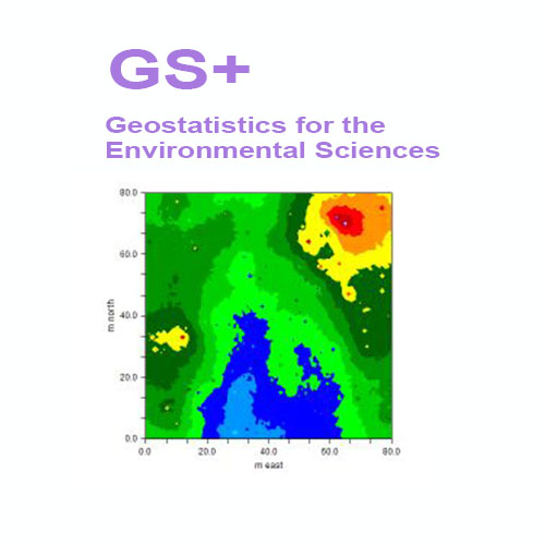
Kriging provides an optimal interpolation of points across an area for which autocorrelation (semivariance) has been documented and measured with variograms or semivariograms. GS+ provides both block and punctual kriging, and allows the user to choose the most appropriate variogram / semivariogram model to use for the interpolation.
What was new in Version 7:
A new interpolation method - Conditional simulation reports z-estimates, standard deviations of estimates, and the likelihood of exceeding some target z-value
7 new autocorrelation measures in addition to variograms, madograms, Moran's I, and fractals: drift, rodograms, correlograms, covariograms, standardized variograms, and pairwise relative and general relative variograms -- all displayed in the same tabbed autocorrelation window
Easier variogram modeling that includes slider controls to immediately visualize parameter changes
h-Scattergram analysis in addition to cloud variance analysis to detect outliers
Improved variogram mapping - faster and more precise
Easy data masking from h-Scattergram and Variance Cloud windows: quickly remove outlier data points from analysis
Improved graph customizations - for example, separate fonts for axis values and titles
GS+ 环境科学地质统计学软件
概述
GS+软件于1988年作为个针对个人电脑和工作站的综合地理统计程序被引入。它很快成为**用户使用的地理统计程序。广受**的是,GS+是个通过集成包提供半方差分析的地理统计软件,它提供了所要求的灵活性和新手所欣赏的简单性。GS+支持从Windows 7到10的操作系统。
今天GS+仍然是地球和环境科学的的2D地理统计软件。它在世界范围内被工业、机构和学术研究人员使用。GS+已被用于数百项空间分析的科学研究。而那些通过ESRI和其他GIS供应商提供GIS软件包的用户更喜欢GS+,因为它可以更全面地访问复杂的分析。输出的文件,可以很*地将导入到GIS数据库和地图中。
快速执行地理统计分析
地理统计学提供了一种方法,可以更好地理解空间数据中固有的自相关,并定义和使用这种变化,以便更好地估计未被采样的地方的值,从而创建优、无偏离的地图。GS+提供了对这些计算密集型分析的简单访问。无论您是在分析石油沉积物、浮游生物分布、太阳黑子模式、性疾病爆发或土壤资源,GS+都能让您随时掌握地质统计学的功能。
Create interpolation output files that are usable by many other programs
GS+ creates interpolation output files (from kriging, cokriging, simulation, or inverse distance techniques) that can be read into many other types of mapping programs. GS+ will use these files to create it’s own maps or you can read the data into any GIS or mapping program that supports ArcInfo® or Surfer® input formats.
Cross-validation allows you to test your interpolation system against sampled data
In cross-validation analysis each measured point in a spatial domain is individually removed from the domain and its value estimated via kriging or inverse distance weighting as though it were never there. In this way a graph of estimated vs. actual values for each sample location in the domain can be constructed and used to test the interpolation system.
Geostatistics is a class of statistical techniques developed to analyze and predict values of a variable distributed in space or time. It begins with a type of autocorrelation analysis called variography or semivariance analysis, in which the degree of self-similarity is displayed as a variogram. The variogram model is used to predict unsampled locations by kriging or conditional simulation, which produces estimates of the variable across the entire spatial or temporal domain
科学软件网不仅提供软件产品,更有多项附加服务免费提供,让您售后**!
http://turntech8843.b2b168.com
欢迎来到北京天演融智软件有限公司网站, 具体地址是北京市海淀区北京市海淀区上地东路35号院1号楼3层1-312-318、1-312-319,老板是赵亚君。
主要经营北京天演融智软件有限公司(科学软件网)主营产品PSCAD, CYME, SPSSPRO, Stata, Matlab,GAMS,Hydrus,GMS,Visual Modflow 等各学科软件,科学软件网有20多年的软件销售经验,提供专业销售和培训服务,还有更多的增值服务。目前,科学软件网提供的软件有数百种,软件涵盖的领域包括,经管,仿真,地球地理,生物化学,工程科学,排版及网络管理等各个学科。。
单位注册资金单位注册资金人民币 1000 - 5000 万元。
我们的产品优等,服务优质,您将会为选择我们而感到放心,我们将会为得到您认可而感到骄傲。